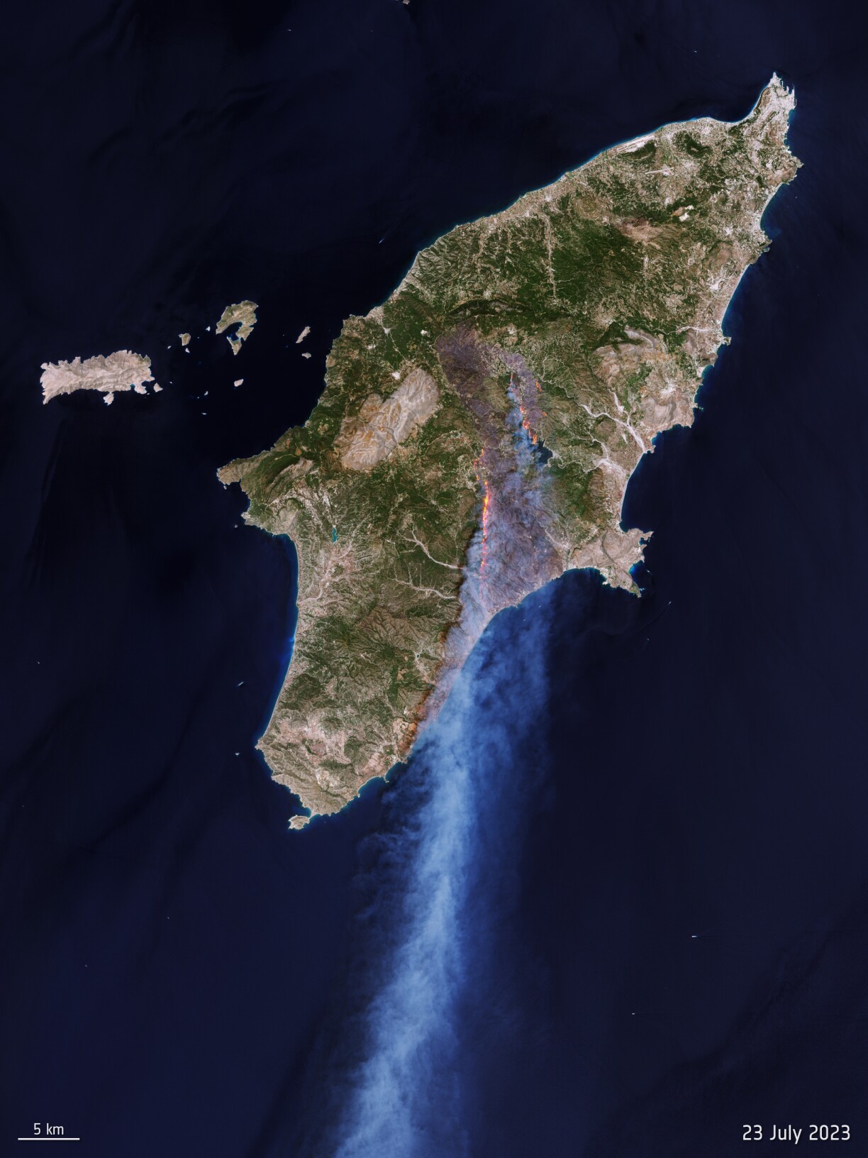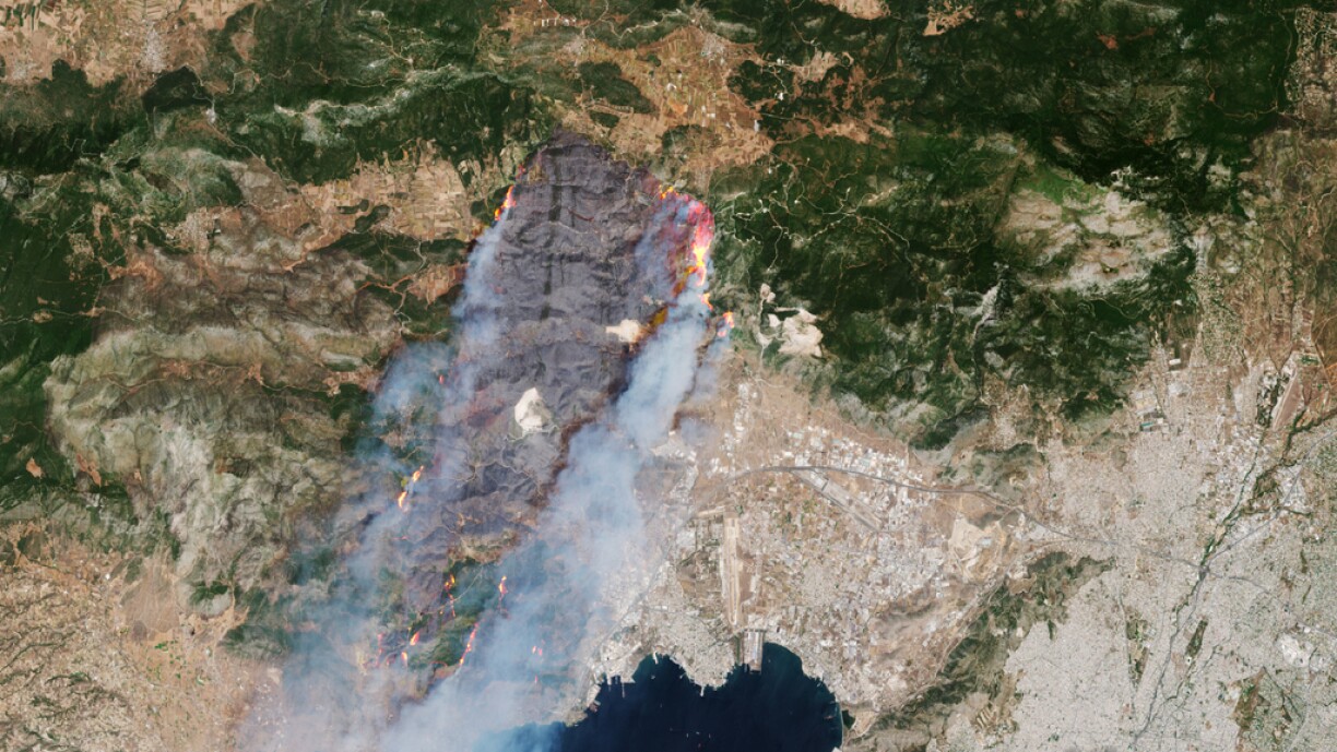
The northern hemisphere has experienced extreme heatwaves throughout July, particularly southern Europe and North America. In Greece, firefighters have battled fires for a week, with a combination of violent winds, prolonged heatwaves, and drought escalating the situation. Tens of thousands of people, including tourists from Luxembourg, have been evacuated from the island of Rhodes.
Images taken by the European Space Agency (ESA) as part of the 'Copernicus Sentinel 2' mission clearly show the movement of flames towards the coast, alongside developing plumes of smoke.
The satellites taking these images are a critical component of the Copernicus programme -- jointly established by ESA and the European Union -- and they play a pivotal role in their ability to offer global data at controlled, snap intervals. They provide a crucial advantage by monitoring the most remote and challenging of locations.
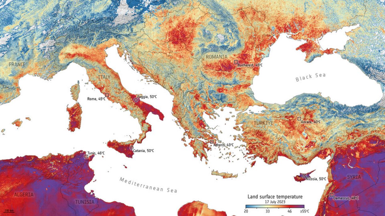
These satellites are also able to measure the Earth's surface temperatures, which often diverge from the temperature of the air.
As explained by research fellow Clément Albergel, from the European Space Agency Climate office in the UK, the sentinel 3 satellite is "equipped with a radiometer that measures surface temperature. However, it is important to note that this differs from the air temperature mentioned in meteorological forecasts. Instead, it represents the actual amount of energy radiated from the Earth, indicating the actual temperature of the Earth's surface. Naturally, high air temperatures influence the temperature values of the Earth's surface, taking into account factors such as canopy type, colour, wind, and cloud cover."
In the face of prolonged and abnormally high temperatures during heat waves, the risk of wildfires increases. ESA satellites play a crucial role in monitoring fire evolution from space and identifying areas at risk of forest fires. In addition, the European Forest Fire Information System (EFFIS) provides the latest information on forest fires in Europe and the Mediterranean. This includes daily updated maps showcasing active or previously burnt areas, along with weather forecasts for fire risk assessment.
Albergel explains the significance of space observations in assessing and forecasting these fire risks, which, when combined with meteorological data, provide valuable insight for decision-making and resource allocation in firefighting efforts.
According to Albergel, fire detection is based on the physical principles of heat and light: the rise in temperature caused by a fire generates a visible signal, albeit short-lived. Changes in the reflection of light from the Earth's surface, such as the darkening of vegetation due to burning, are less apparent from space but persist for extended periods, often lasting months or even years after the fire.
Albergel stresses that the ongoing heat waves are clearly influenced by human activities. While meteorological factors like El Niño contribute to heat wave intensification, the primary driver of climate change continues to be man-made emissions and the burning of fossil fuels.
Recently, the international network of scientists known as 'World Weather Attribution' published a study revealing that frequent, intense, and prolonged heatwaves in Europe would be "impossible" without "man-made global warming." Satellites play a crucial role in advancing our understanding of these extreme weather phenomena.